


The Ferghana Valley: The Pre-Colonial Legacy
By Abdukakhor Saidov with Abdulkhamid Anarbaev, and Valentina Goriyacheva

Editor's Note: Following our previous post about the historic January 2025 trilateral meeting of Central Asian prime ministers, we continue our exploration of the Ferghana Valley's significance by sharing Chapter One of 'The Ferghana Valley: The Heart of Central Asia.' This chapter reveals how the valley's unique geography and natural resources have shaped human settlement and regional dynamics for millennia. As current leaders work to foster unprecedented cooperation across the valley's modern borders, understanding its physical characteristics and historical legacy becomes even more relevant. The natural pathways and barriers described by the Mughal emperor Babur continue to influence regional connectivity today, while the valley's rich agricultural potential remains central to its economic importance.
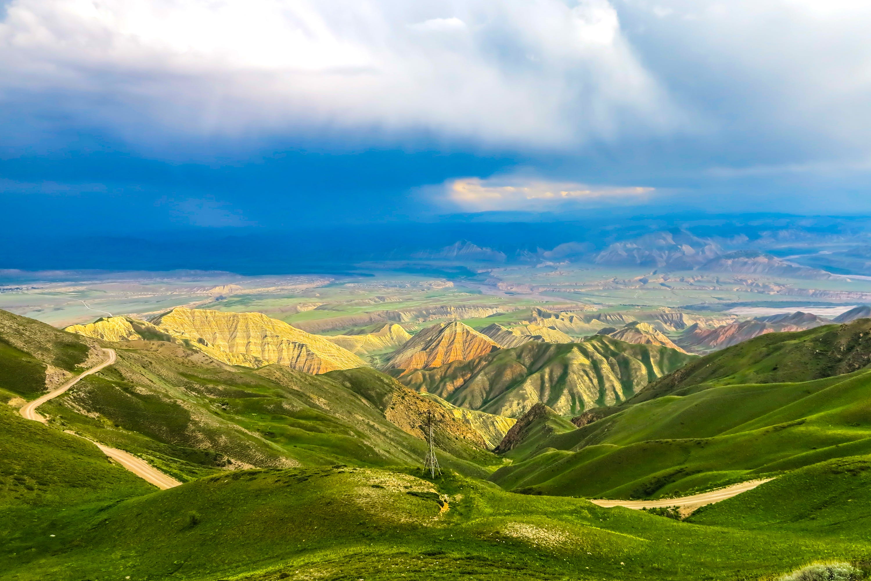
The Ferghana Valley, surrounded by mountains on all sides, is one of nature’s unique regions. The intermountain plain—the Ferghana Valley itself—was formed a million years ago by a lifting of the earth’s crust. It is bounded on the south by the Alai and Turkestan mountain ranges, on the east by the Ferghana range, and on the north and west by the Chatkal and Kuramin mountains. A natural route to the west provides the sole link between the Ferghana Valley and the rest of Central Asia, which is why the Mughal emperor Babur, himself a native of the valley, wrote that the Ferghana Valley is wide open to attack from that direction throughout the year.
Here almost all types of natural landscapes are found, from the sand dunes of central Ferghana to alpine meadows. The valley is distinctive for its dry, continental climate. The high mountain ranges form a natural barrier for water-saturated air masses, which inhibits rain from reaching fields in the heart of the valley. Despite this, the region is able to sustain both agriculture and cattle raising.
The valley is defined by the basins of the Syr Darya, Amu Darya, and Naryn rivers, with the Syr Darya being the valley’s largest. Formed at the junction of the Naryn and Kara Darya rivers, its waters flow from east to west across the entire valley, separating it into uneven northern and southern areas. Many run-off channels flow into the Syr Darya from the surrounding mountains, creating in their deltas favorable conditions for human life. The mountains are rich in juniper, hazelnut, hawthorn, and other fruit and berries, as well as diverse fauna.
The Ferghana Valley was initially an agricultural region separated from the nomadic tribes by the encircling mountains. Over time the cultures of farmers and nomads melded together into a single, inseparable history. The Davan kingdom was but one of many societies created there through such symbiosis. These processes led gradually to the mutual enrichment of cultures, values, and traditions among the peoples living on this territory. This imparted to them a common identity that was preserved through the centuries and came to define the Ferghana Valley as a whole.
The first signs of irrigated agriculture in Ferghana date to no later than the fifteenth and sixteenth centuries bce, that is, during the late Bronze Age. At the time two cultures coexisted there: one agricultural—the Chust—identified by its painted ceramics; and the other cattle breeding—the so-called Kairakkum—with its ceramics drawn from the steppes. In the middle of the second century bce, a new pastoral culture from the steppes made its appearance in the southern foothills of the Ferghana range and the north of the Alai ridges. This formed part of the Andronovo culture that was widespread in Eurasia.
The remains of more than 80 settlements of the agrarian Chust culture have been discovered. These were situated along rivers on the large, isolated oases at a typical distance of 20–30 kilometers from one another. Thus, in the Uzgen the largest late Bronze Age remains in the Ferghana Valley is the site at Dalverzin, which consists of three parts surrounded by separate defensive walls. The citadel comprises 2 hectares. Its 2.5-meter thick fortification wall is built on the occupation layer and reaches up to 2.6 meters in height. The inner city, with an area of eighteen hectares, is surrounded by a 6-meter defensive wall built on a special platform from adobe bricks (pahsa) and rammed earth. Under this base have been discovered occupational layers up to 0.8-meters thick. Inside the fortification, three types of habitations corresponding to the three periods of settlement have been found: frame houses, wattle-and-daub houses, and dugouts. The outer city, with an area of about 5 hectares, was used as a shelter for cattle.
Iurii A. Zadneprovskii delineated three long periods in the history of the site. The first witnessed an unfortified agricultural settlement; in the second period, fortifications were constructed; during the third period, the fortifications were no longer functional and occupational layers appear above them. Carbon 14 analyses indicate that Dalverzin existed for about 800 years, that is, from the fourteenth or fifteenth to the eighth or seventh centuries bce. Diverse types of cultural materials were found there, including ceramics, copper, bronze, stone, and bone.
Sometimes fragments of ceramic pottery were also found. Tableware painted with a black-gray glaze is one of the most significant signs of the Chust culture. These were adorned with geometrical designs, painted with black paint over a bright red background. The motifs of these ornaments were made up of triangles and rhombuses; there were various ribbons filled with diamond-shaped drawings, circles with dots in the center, and the like. The entire array of ornaments was crafted with such deliberation that one can safely assume that even the most simplified variants of these ornaments carry certain semantic meanings.
The remains of a foundry workshop, a crucible, a clay nozzle, slag, a series of casting moulds, and a variety of metal tools indicate the development of metallurgy using copper and bronze. Researchers attribute the wide development of bronze metallurgy to two factors: the presence of copper mines in the Ferghana Valley and the influence of the Andronovo steppe tribes, among whom metallurgical manufacturing was widespread.1 On archaeological digs more than a thousand stone tools have been found, including crescent knives, graters, burnishes, and various seed grinders. Bone products are of equal interest: notably bone combs for nailing down the wefts on a weaving loom, various parts of horse harnesses, and a number of astragals were found.2
The Chust settlement at Burnamozor, with a walled area of about five hectares, was located in the northern Ferghana on a terrace of the Gavasay. Recent research shows that the Chust culture cultivated the most favorable lands in the valleys of such rivers as the Karasu, Kara Darya, Ak-Bura, Margilansai, Gavasay, Kasansai, and others.3 Here, as in Dalverzin, three types of dwellings were discovered: frame houses, wattle-and-daub houses, and dugouts. The ceramics, metal, stone and bone products excavated there all are very similar to the findings at Dalverzin. It is important to note that, unlike in Dalverzin, in Chust there is no black-gray glazed tableware, nor are there any iron artifacts.4
Among the Chust monuments, the Osh (Sulaiman-Too Mountain) settlement stands out.5 It consists of dwellings with in-house pits, fireplaces, production complexes, and a sanctuary, and is located on the terraces around the mountain peak, covering an area of more than 2,000 square meters. Fifteen inhabited terraces were unearthed, cut out of rock, with the foundation pits of the semi-dugouts at a different depth, along with earthen wattle-and-daub houses and wooden constructions of rush-and-clay covers.
Most of the constructions of the Osh settlement had not been inhabited, but were used instead as industrial facilities, with more than 200 storage pits for grain and other supplies having been discovered. According to Zadneprovskii, this part of the Osh settlement was considered a highland sanctuary and its terraces were places for performing rituals related to the worship of the mountain, or perhaps to a proto-Zoroastrian cult of the sun, fire, and water. A considerable quantity of painted ceramics and about 76.3 percent of the total number of structures on the Sulaiman-Too Mountain warrant the conclusion that it was the original cultural ideological center of all the Chust culture of Ferghana.6
Archeologists assume that in the eighth and seventh centuries bce some hundreds—and in other places, thousands—of hectares of fertile land were devoted to agriculture. This led to an increase in food production, greater social differentiation, and the start of urbanization. Probably in this period the first political associations or rudiments of statehood occupying the territory of one, two, and sometimes even three irrigational regions—oases—began to emerge. Dalverzin and Chust were the centers of these political developments. Later, perhaps in the tenth and ninth centuries bce, “centralized” and considerably large state-type entities appeared.7 This was supported by an agricultural system that produced wheat, rye, and millet and had domesticated cattle, horses, donkeys, dogs, and camels.8 It was probably at this time that the first iron tools appeared.
The agricultural tribes of the south and the southwest also played a role in the formation of the Chust culture in Ferghana. Some findings are testaments to this, such as stone images of snakes with Elamite origins found in the Sokh region,9 the Haksky treasures,10 and bronze relics from Aflatuna.11 The remains of a cattle raising culture were found in the foothill zones of western and southern Ferghana. The nomadic culture of Ferghana is more similar to the culture of the peoples from Semireche (Seven Rivers) and the Central Syr Darya regions. The intersection of these two cultures is reflected in the appearance of the nomads’ earthenware in various towns.12
The early Iron Age began in the eighth century bce and lasted to the third century bce,13 an era known to archeologists as the Eilatan or Eilatan-Aktam period. There were no written records from this era in Ferghana but the archeological finds suggest how closely the excavated settlements conform to descriptions in the Zoroastrians’ holy book, the Avesta. One commonly finds in the Avesta such concepts as a “housedwelling family” and a “generational-patrimonial settlement,” which are similar to the Chust groups and with the social structure of ancient Iranians generally, with its three carefully delineated estates: soldiers, priests, and farmers-cattlemen.
The site of ancient Eilatan is a good example of the urban growth in the early Iron Age.14 A planned area, it is an irregular quadrangle of defensive walls with towers. The area of the inner building is twenty hectares. The fortifications have a thickness of four meters. At a distance of 500 meters from it, there is a second external wall protecting the city’s arable lands and a shelter for cattle measuring 200 hectares. Another urban settlement of the same type—Nurtepe—was excavated in the Ura-Tyube region.15
In southern Ferghana, the remains of monumental architecture were excavated at the urbanized settlement Symtepe, which was founded in the fourth century bce. Natalia G. Gorbunova16 and others have uncovered nearly a dozen major burial grounds from the sixth to the fourth centuries bce; nearly all of them were earthen graves with the bodies oriented to the west and accompanied by niches with ritual food. This further strengthens the conclusion that by the Early Iron Age in the Ferghana Valley a unique agricultural and cattle-raising culture existed, with comprehensive social and religious institutions.17
By 800–400 bce an integrated system of trade put the people of Ferghana into cultural contact not only with neighboring cattle-raising peoples but also with the more developed civilizations of the Asian Near East, but both Greek and Persian and Greek sources are silent on whether Ferghana actually became part of the Achaemenid Empire. Conversely, they were in close contact with the Saka tribes,18 who founded the Davan kingdom of which the Chinese chronicles have much to say.19
Antiquity (Fourth Century bce –Fourth Century ce)
The first written information on Ferghana appeared in the second and first centuries bce in the Chinese chronicles, written as an account of the westward travels of the famous diplomat Chang Ch’ien in 138 year bce. The fundamental sources of our knowledge about the population of Ferghana are the Shih Chi (Records of the Grand Historian) and Han Shu (Book of Han).
Shih Chi contains information about events from 138 to the 90s bce. The author writes that: “the Davan people lead a settled life, engage in agriculture, sowing rice and wheat. They have grape wine. Their horses have bloody sweat and come from the breed of heavenly horses. There are up to 70 large and small cities in Davan, with populations reaching up to several hundred thousand. Their weapons consist of bows with arrows and spears. They are skillful with the horse bow.”20
The Han army, led by the commander Li Guang, twice visited Ferghana. The first time they reached Yucheng City (Yu); the second time Li Guang attacked Ershi—the capital of Ferghana—with a large force and, after a forty-day siege, the inhabitants agreed to surrender horses to the Han court. Here, only two large capital cities—Ershi and Yucheng—are mentioned.
The Shih Chi is not free of inaccuracies. For example, its statement that the Ferghanans and their neighbors learned how to produce (to cast) weapons from a Chinese refugee is contradicted by much archaeological evidence. Moreover, the Chinese source claims that when the people of Ferghana received gold and silver from the Chinese they used it to make tableware instead of coins, when actually they had been minting coins for centuries.
The first-century source, Han Shu, describes events from 138 bce until the year 23 ce. The author of Han Shu, Ban Gu, used the Shih Chi information, and enriched it with some new facts. In particular, he reported that the Davan emperor resided at Guishuang City and that the Ferghanans used silk and varnish.21
The next historical source, the Hou Hanshu (fifth century ce), covers events from 25 to 221 ce, when there were clashes for leadership across East Turkestan. From 23 ce Davan paid tribute to Yarkant but still recognized the supreme power of the Han dynasty. Later, in 130 ce the Kashgar emperor seized power and thereafter sent his ambassador, along with envoys from Yarkant and Davan, to the Han court.22
In the Bei Shi (400–600 ce), Davan is referred to as “Lona, the ancient province of Davan, with its imperial residence in Guishuang city.”23 The Chinese chronicles mention only three large cities in Ferghana: Ershi, Yucheng, and Guishuang. Some scholars place Ershi City at Ura-Tyube; others put it at Kokand24 and still others at Osh,25 but most accept Alexander Bernshtam’s placement at the Markhamat ruins in Ming-Tepa. Similarly, some scholars place Yucheng City somewhere in Uzgen,26 others on the site of the ancient settlement of Shurabashat,27 and the rest near Osh or Uzgen.28 Bernshtam puts Guishuang at the ancient settlement of Mug-Tepe (Kasan);29 Edwin G. Pulleyblank notes that the Guishuang or Kushan tribes renamed the capital of Davan as Guishuang.30 Chinese sources provide only standardized figures on population; for Davan, as an example, “the population consists of 60,000 families, 300,000 heads; 60,000 soldiers.”
Excavations at Eski Ahsi (Ahsiket, Ahsikent, Akhikent) and Eilatan lead us to propose that Ershi, the ancient capital of Ferghana, was in fact Eski Ahsi.31 The large area of the inner city, which includes two shakhristans; the 40-hectare citadel; the 10-hectare suburb as well as its 20-meter high walls,32 exceed all other remains in Ferghana.33 By the third and fourth centuries ce the thickness of Eski Ahsi’s walls at the base had reached 7.5 meters.34 Thus, during and after the two main Chinese incursions into Ferghana, the local populace strongly reinforced its capital, working for nearly 100 years to construct the two large walls and smaller double ditches. The resulting defenses were formidable indeed, reaching a thickness of 20 meters with an overall appearance of a collection of towers.
The author of the Shih Chi notes that the second city of Ferghana, Yucheng, was located at 200 lee (50–60 km) to the east of the main city of Ershi. The best candidate for this site is the ancient settlement of Eilatan. It was probably destroyed during the second Chinese campaign against Ferghana, losing its big-city status after 90 bce. Kasan was apparently the summer residence of the kings of Ferghana and was called by the same name as the main capital, Guishuang.35
Irrigation-based farming served as the main economic activity of the FerghanaDavan people. The deep channel of the Uzgen-Aryk, which still exists today, dates to this time. Large underground storage pits attest to the productivity of their farming.
The gracefully shaped and thin-walled ceramics of ancient Ferghana reveal some interesting features. On the one hand, there is a big difference between the elegant products of the urban centers and rural towns.36 On the other hand, while the new technologies of the best urban ceramics reveal influences from the Middle East, the traditional regional decorations of the Chust culture (harrowed ornaments and red-engobed color) were continued from the first to fourth centuries ce, suggesting a strong capacity to assimilate new influences from abroad.
Mention has been made of the highly developed Ferghana art of viniculture. Because it was new to them, the Chinese wrote of it in detail:
In Davan, the wine is made from grapes. The rich store up to 10 000 dan (1 dan is more than 80 kg). The old wine can be kept for decades without deterioration. Residents enjoy wine the way their horses enjoy the Moussa (alfalfa) grass. Chinese envoys exported the seeds, and the Son of Heaven issued orders for his subjects to plant both Moussa and grapes in rich soil.37
Ferghana’s interactions across Eurasia intensified in ancient times. Finds of ushu coins, Chinese mirrors, basketry, bronze items, and fabric38 testify to relations with China. A famous mirror handle in the form of an Indian dancer39 and two bronze pendants from burials at Kara-Bulak and Tour-tash40 attest to links with India. Red-decorated vessels from the second to the fourth centuries bce41 reflect Ferghana’s trade relations with the Middle East. Meanwhile, wooden utensils and bronze cosmetic devices found in graves in Talas, Tian Shan, and Alai mountains42 attest that the people of Ferghana had constant contact with the nomadic tribes living in nearby mountain valleys and on the steppes.
A fourth to sixth century ce estate excavated at Kayragach in western Ferghana shed light on both the art and religion of these early Ferghanans.43 Here were found small groups of painted alabaster statuettes—local idols and gods, which are very specific to this historical and cultural region. All have sharply beveled foreheads, large convex eyes, straight noses with a crook, straight eyebrows converging in the bridge of the nose, and small mouths. The sculptures of idols and local deities from the Kayragach estate stood in a special niche in a building of the fifth and sixth centuries ce that served as a sanctuary as well as a place of worship for the tenants. Twelve sculptures from 16 to 67 centimeters were found, all of alabaster, with disproportionately large heads and narrow shoulders. The Kayragach sculptures are likely portraits representing specific people, apparently respected ancestors.
N.G. Gorbunova wrote of ethnic assimilation of such diverse tribes as Sakas, Usuni, and Kangju44 and the gradual emergence of a specific Ferghana people by the fifth to seventh centuries ce, with its own eastern Iranian language. The King of Ferghana bore an Iranian title ishhid, and was connected to all the main landowners in the villages and city-states. Starting from the time of Alexander the Great Sogdians had colonized Ferghana, bringing with them the Sogdian spoken and written language, based on which there could also have been a Ferghanan writing system before the penetration of the Aramaic and then the Arabic in the early Middle Ages.
The Early Middle Ages (Fifth to Eighth Centuries ce)
During the early medieval period, Sogdian-Turkic traders reached China, Korea and Japan; as well as the Mediterranean, Iran, India, and Ceylon. The Sogdian language became the language of international trade and communication. Using the Great Silk Road, people transported silk, precious stones, gold and silver jewelry, ornaments of colored glass, pharmaceuticals and paint, thoroughbred horses, and various fruits. Along these routes there also passed religious missionaries, master craftsmen, musicians, actors, and artists. The palace feasts of Chinese emperors were accompanied by performances of dancers and singers from Ferghana, Sogdiana, and Chach (Tashkent), while Central Asians judged their wealth by the quantity of Chinese silk they owned.45 By the sixth and seventh centuries ce, Ferghana also practiced sericulture, fragments of which have turned up in various European treasuries.46 But silk was only one among many valuables exported from Ferghana. In 479 Ferghanans reciprocated a visit by Chinese ambassadors by sending to that realm an embassy that brought their famous horses as gifts.47
The Ferghana Valley became increasingly Turkicized during the late Kushan period between the late 500s through the 650s ce, as the Western Turk state extended its authority there.48 The Turks successfully played off the various citystates against each other. They met strong resistance but eventually established new Turkic dynasties at Kasan and Ahsiket, called Gesay and Sigyan by Chinese sources.49 Shortly afterward, the Arab conqueror Kutaiba attacked the country, leading punitive raids against Turks in alliance with the Tibetans. It looked briefly as if a Ferghana-Chinese alliance might lead both the anti-Turk and anti-Arab resistance. The Ferghanans entered into an alliance with China, which repelled the Western Turkic Kaganat and subdued Ferghana, renaming it Ninyuan. But in 739 ce the Turkic prince Arslan Tarkhan took control of Ferghana away from China, and thenceforth headed the anti-Arabic movement.
By the seventh century ce, Sigyan (Ahsiket) had again become the major city of the Ferghana Valley,50 with only two other Ferghanan cities—Gesay at Mug-tepe and Humyn—figuring in the Chinese chronicles.51 In the first quarter of the eighth century ce, the Arab writer al Taraba mentions five Ferghana cities.52 The eighth century “Sogdian Documents from the Mug Mountain” report the existence of a king of Ferghana and a Ferghana tutuk (representative). Foreign sources of the 500–700 period refer to Ferghana as Faihani, Bohan, Pahana,53 with its capital at Ferghana which, as argued earlier, must be the same as the Eski Ahsi settlement at Ahsiket.54
The other capital city of Ferghana at that time was the city of Kasan, now Kasansai, where the tutuk of the Western Turkic Kaganate lived. This trapezoidalshaped city occupied several high hills on the Uzbek side of the Uzbek-Kyrgyz border. This strongly fortified town, with six towers, had arisen in the first century bce and was now one of the most defensible places in the entire region.55 A third urban center of the early Middle Ages was Kuva, a classic three-part Central Asian settlement with citadel (ark), inner city (shakhristan), suburbs (rabad), and a major Buddhist temple that functioned as late as the eighth century ce.56 The regional governor resided here.57
All these cities gradually evolved from being mere castles with settlements attached to being the economic and social centers of entire oases. They drew the entire life of their respective oases into their well-developed markets, streets, and buildings.58 Religious life in this last pre-Muslim era centered at the Sulaiman-Too Mountain near Osh, dubbed by Chinese chronicles the “city of the saints, or highly sacred Mountain.”59
The Turkic conquest of the valley led to a new phase of its development. Numerous examples of Turkic runic writing have recently been found in cemeteries and elsewhere, suggesting that Turks’ role expanded from politics into culture during the early Middle Ages.60 Their rule also fostered improvements in animal husbandry, creating more effective animal power for farming and manufacturing.61 The Turks’ arrival did not disrupt the continuity of Ferghana’s royal dynasty. Continuity helped Ferghana rulers grow more powerful and to oppose any form of mutual subordination.62 Thus, on the eve of the Arab conquest, Ferghana thrived as a powerful and self-confident land based on economically prosperous city-states but without a powerfully centralized administration and with inter-city competition the order of the day.
The first campaign of Arabian conquest took place in 712 ce, headed by Kutteiba ibn Muslim. Citizens of the Ferghana strongly resisted. In 715 ce Kutteiba attacked Ferghana for the second time and also rebelled against his own caliph, Suleiman (715–717 ce). But his troops did not support him and he was soon killed. Locals still point out his grave in the village of Jalal Kuduk near Andijan.
The Arabs left governors in Ferghana and other places to lead local troops and collect taxes; however, the people of Ferghana remained independent, relying on the strength of the Turkic tribes. Around 720 ce Ferghana was ruled by a strong king named Alutar. In 723 ce, he linked up with other Turkic forces from Chach (Tashkent) to strike a blow against the Arabs, chasing them the entire way to Samarkand. A few years later another Turkic leader, Arslan Tarkhan,63 ruled all Ferghana and developed friendly relations with the Chinese.64 Mansur (754–775) forced the king of Ferghana to live in Kashgar and levied an annual payment on him. However, the Ferghanans still resisted politically and militarily, and they refused to meet the Arabs’ major demand—to embrace Islam. Under Caliph Mamun (813–833) the Arabs sent troops once more against the population of Ferghana. In the end Mamun granted governance over Ferghana and certain other provinces to the Samanid dynasty of Samarkand, but even this did not mark the Arabs’ last effort to subdue the region.
The Political Situation in Ferghana from the Ninth to the Seventeenth Centuries
From 819 to the tenth century ce, Ferghana was part of the Samanids’ kingdom and Ahsiket remained its capital. In 992 ce, Ilias ibn Ishak started an uprising against the caliphate in Ferghana, enlisting in his project, among others, the Qarluq Turks. The Tahirid dynasty that eventually stifled this rebellion by “the enemies of the Faith,” (the Qarluq Turks) would build a new capital for the valley, which they named Nasrabod and surrounded with gardens.65 After the death of Asad, the ruler of Ferghana, the caliph appointed Asad’s son, Ahmed, to rule the territory. At that time Ferghana was an economic and cultural center, later to become a political center as well. Coins were minted at both Ferghana and Nasrobod in the name of the local leaders and their Samanid overlords.
Starting from the middle of the tenth century ce, Ferghana was ruled by high local dignitaries who remained independent of their nominal masters in Samarkand. The local copper coinage did not bother to mention the Samanids. All the traditional leaders of principalities within Ferghana had the status of emirs and starting from the middle of the tenth century ce they acquired the further title of “Client of the Master over the Faithful.”66
At the end of the tenth century Ferghana fell to the invading Karakhanid Turks. Since ancient times Turks had wielded military and political power in Ferghana. Now the Karakhanids made the city of Uzgen their capital, sustaining the prosperity that had prevailed under the Samanids. In 999 they consolidated regional power by seizing the Samanids’ capital of Bukhara.67 Prosperity led to a proliferation of mints, which were maintained at Ahsiket, Margilan, Osh, and Kuba, as well as Uzgen. In 1001 an alliance was struck with another rising Turkic ruler, Mahmud of Ghazni, who already ruled Afghanistan and was soon to conquer India.68
The eleventh century witnessed various feudal wars among rival Karakhanids, the stakes including not only control over Ferghana but of the other Karakhanid holdings as far west as Bukhara and as far east as Kashgar. Each shift in power brought about a move of the mint, which was based at various times in Ahsiket, Uzgen, and elsewhere.69
In the twelfth century Uzgen continued strengthening and protecting its position as the capital of Ferghana. The results of this are the beautiful ornamented brick tombs and minarets that survive there today. Uzgen maintained its status as a mint until 1178.70 Soon after 1212 ce the entire southern part of Ferghana was conquered, ruled, and at times decimated by yet other Turkic groups, one from Khorezm in the western part of Central Asia and the others, the Karakitai, from East Turkestan. This was a prelude to the Mongol conquest after 1219. Ismail, the ruler of Ahsiket and Kasan, quickly expressed his obedience to Genghis Khan’s military commander and thereby saved his cities. But not everyone did the same. Khujand, the western gateway to Ferghana, resisted bitterly and was destroyed. Not breaking with tradition, Mongols eventually situated their local capital at Uzgen and placed their treasury there.
The Mongol conquerors devastated Ferghana along with other provinces of Central Asia. Only at the start of the thirteenth century did the process of economic revival take hold. Before the Mongol conquest, silver-covered copper dirhems minted in Ferghana, Uzgen, Merv, and elsewhere had been the main currency circulating in Central Asia. At the end of the twelfth century ce, however, a deep currency crisis began in Ferghana, exacerbated by the economic blow the Mongol conquest had inflicted on Ferghana and other parts of Central Asia. The crisis of silver-covered copper dirhem went so far that Mahmud Yalavach, the merchantruler of Ferghana, made no effort to restore the monetary trade and did not even try to return to the use of dirhems.71
By now Ferghana had become thoroughly Muslim, and the Mongols had reason to fear that, as non-Muslims, they might have trouble sustaining their rule there. What most weakened the Mongols was infighting between successors to the far-off throne. Timur the Lame (also known as Tamerlane) capitalized on this situation by conquering Ferghana in 1370–71. After the conclusion of his eastern campaigns in 1404 ceTimur delegated control over East Turkestan (now Xinjiang in China) to his governor in Ferghana.72 But the division of large Turkic empires into principalities continued after Timur, when a unified Ferghana left to one of Timur’s sons began to break apart.73 By the fifteen century competing coins were being minted in Andijan, Margilan, Osh, and Khujand, with economic interests clearly ascendant over any aspirations for political independence.
In 1479 the local throne in Andijan fell to an ambitious eighteen-year-old, Sultan Ahmed, the son of Abu Said, who promptly began launching attacks on the Mongol’s suzerain, Omar Sheikh, who in turn allied himself with the Mongol ruler Yunus Khan. After several years of exceedingly complex maneuvers, in which the point at issue was who would attack Samarkand and who would remain in control in Ferghana, Timur’s heir in Ferghana had managed to bargain away province after province in order obtain for himself a secure rule in Andijan. Eventually this pitiful ruler was sending his neighbors to attack his enemies74 while he himself stayed home and amused himself on the roof of his pigeon house. When he unexpectedly fell to his death, much of Ferghana became a theater of feudal war.75 Eventually a mere twelveyear-old, Babur of Ahsiket, became ruler of the principality of Ferghana. Rulers from as far afield as Kashgar in Xinjiang also vied for the various parts of Ferghana. When Babur’s father emerged victorious he distributed lands, titles and money to his loyal beks according to their status.76
The Ferghana Civil War and Its Legacy
The minute Babur’s rule began, these local emirs initiated a bitter, multi-sided civil war among themselves. Babur lost Samarkand but was eventually reinstated there in 1497, at which time the emir who ruled Ahsiket rebelled against him and gained the support of one of Babur’s own military commanders, Sultan Ahmed Tenbel, the ruler of Osh. The rebel emirs entered Andijan and surrounded the city. The nobility of the city sought help from Babur, but he arrived too late to save them.
The ruler of Margilan city, Ali Dust Tagai, sent his ambassador to Babur and promised to give the city to him. After strengthening his positions in Margilan, Babur directed his forces to overthrow Uzun, Khasan, and Tenbel. The latter ones, after receiving this news about Babur’s arrival to Margilan, left Andijan and engaged Babur’s troops. After a brief peace, the war for the throne of Andijan between Babur and his former general Tenbel, a Mongol officer, reignited. In 1500 Babur and Tenbel finally made a deal dividing Ferghana along the Syr Darya, but with the understanding that if both sides joined in a successful attack on Samarkand, Babur would leave Ferghana.77 This promptly broke down when Tenbel reconquered Ferghana for himself. In 1503–4 Babur entered Ferghana with the Mongolian Khan Sultan Mahmud and 30,000 troops.78 Soon the whole of Ferghana territory except two capital cities, Andijan and Aksu, submitted to the Mongols. Just when Babur seemed on the verge of success, yet another Turkic force, that of Shaybani Khan, appeared on the scene from the west. Ever more intricate alignments of forces ensued, with Babur fighting Tenbel, who aligned with the Shaybani Khan, until the latter achieved a final victory, after which Shaybani Khan, for tactical reasons, rewarded none other than Babur’s enemy, Tenbel.79
This multi-year intra-Turkic war over the Ferghana Valley had profound consequences. First, it drove Babur out of his native land to Afghanistan and eventually to India, where he launched the renowned Mughal dynasty, in effect exporting a political and cultural ideal from the Ferghana Valley to the Indian sub-continent. Second, it left Ferghana politically divided, so that outsiders, the Kazakh sultans, could take control of a major part of the valley in the seventeenth century. Worst of all, it shattered the economy and social cohesion of the valley, inflicting a blow from which it would not recover for many centuries. As a result the valley faced the challenges of the modern world in the nineteenth century divided and in a greatly weakened condition.
Even the name of Ferghana fell out of use and was replaced with Andijan. By the end of the seventeenth century, local hojas, the descendants of earlier Arab conquerors, took control.80 The temporary capital of Ferghana became an insignificant village named Chadak (“close to the hojas”) located on northern side of the Syr Darya River 60 kilometers northwest of Ahsiket. Only in 1709 was their power destroyed when they were driven from power and an independent Uzbek Turkic state established in Ferghana, with its capital at Kokand.
Cities, Trade Routes, and Raw Materials
The Ferghana Valley, as noted, is comprised of distinctive inter-mountain hollows, bordered by the Kuramin and Chatkal ridges to the north, the Ferghana ridge of the Tian Shan Mountains to the east, and the Alai and Turkestan ridges of Pamir Mountains to the south. In the western part of the valley there is a narrow pass called the “Khujand Gates” through which the valley merges with the Turan lowlands.81
Throughout its early history Ferghana was one of the more economically developed regions of all Central Asia. Almost all lands on the western side of the Ferghana Valley through Ak-Bura (one of the tributary of Syr Darya, also called the Osh River) and on the east up to the Syr Darya had been divided into two districts: Upper Nesya including Kokand, Rishton, Vankent, and Sokh; and the Lower Nesya including Margilan, Andijan, Isfara, Zenderamsh, Nookat, Jidgil, and Urest.
That part of Ferghana located between the Kara Darya (Upper Syr Darya) and Haylam (riverhead of the Naryn River), was known as Miyan-i Rudan (between two rivers). Bordering it were Biskend and Selat, as well as the Haftdeh area (seven settlements), which was conquered by Muslims only in the tenth century. The main city in this sub-region was Haylam, which had a beautiful mosque.82
From medieval written sources we see that the number of Ferghana cities varied from twenty-four to forty. Typical of the broader region, all of them were comprised of three parts named kuhandiz (old fortress), shakhristan (inner city), and the rabad (external town). Important centers within these sectors included the palace of the ruler, the Friday mosque, bazaars, and the prison.
The cities of Kend (Kanibadam), Sokh, Rishtan, Zenderamsh, and Kuva (Kuba) stood on the main road from Khujand through Osh. Kuva was the second city in Ferghana because of its abundant amount of water and gardens, exceeding even Ahsiket in wealth and outnumbering in population the city of Osh. The mosque was in the citadel while the bazaars, palaces, and prison were all located in the rabad.83 Each main city, like Kuva, was the business center of its entire region. Near Sokh, with its two gates, were up to sixty villages and towns, including the cities of Kokand and Vankent.84 This comprised the most densely settled area of Upper Nesya.
Of the Lower Nesya cities, the largest one was Margilan. During the Samanid period Margilan remained small, with only the single trade road leading through it to southern Ferghana. But during the Karakhanid period, Margilan became one of the important cities of Ferghana on the strength of its mint. The Silk Road passed through Khujand, where it split into a northern and southern route. The southern route passed through Kanibadam to the mining district of Solh, then from Haydarken to Ohna, Kadamjai, and finally reaching Margilan. The northern route split routes beyond Ahsiket, with one route passing through Mion Rudan to Uzgen and the other running to Margilan.85
Andijan (also called Andujan, Andugan, Andikan, and Andigan in medieval sources) was among the Lower Nesya cities. The Mongol conquest devastated the city and left it desolate for many years. Only by the end of the thirteenth century was Andijan rebuilt and resettled.86 In the fourteenth century a defensive wall was erected around the city and remained functional until the eighteenth century. From the end of the fourteenth century, during the Timurid dynasty and up to the eighteenth century, the rulers of Ferghana, with independent authority granted them by the reigning supreme powers, had their seat at Andijan, to which the capital was moved from Ahsiket. During that period, the city of Andijan became so dominant in the region that people came to call the inhabitants of Ferghana and East Turkestan “Andijanians.”87
The mountainous part of Ferghana, the third row of towns on the caravan route from Kuva to Margilan and Andijan, encompassed the following districts:
a. Isfara, located to the north of the present-day village of Isfara, was in a mixed mountain and valley area five farsahs88 from Sokh, and known for its coal fields.
b. Aval, which still exits south of Margilan, the capital of the district of Aval, was situated within ten farsahs from Osh and bordered by Margilan to the south and ten farsahs from Solh en route to Uzgen.
c. Nookat was seven farsahs from Kuva. And included as part of its region the town of Miskan.89
Osh, approached by Urest to the east and Urshab on the way from Uzgen,90 was the Turkish-ruled border city of Ferghana and the third city by size after Ahsiket and Kuva. It had a mountain gate, a river gate, and a Mugkede, or “gate of the fireworshippers.” The mosque was situated between the bazaars.91 The city of Uzgen was smaller in size than Osh, and distinctive in that the citadel made up part of the shakhristan in Uzgen. This city had four gates. Trade with the Turks brought major income to the city, especially under the Karakhanids. The city was located on the important route connecting Ferghana with the Tian Shan Mountains, in particular, the town of Atbashi (present-day Kyrgyzstan) through the Yassi and Gugart passes. Atbashi briefly served as the capital of Ferghana in the seventh century ce.
Ahsiket, the center of Ferghana in the ninth and tenth centuries, was located in the north of Ferghana on the right bank of the Syr Darya and on a crossroads of the Great Silk Road. The city’s mint issued embossing coining dies for the Samanid state in the ninth and tenth centuries ce.92 The palace, prison, main bazaar, and mosque were all located in the shakhristan near the citadel. The city was surrounded by five gates and was irrigated by a multitude of canals that fed beautiful bricked reservoirs (hauzes), traces of which remain on the site. The banks of the canals were also bricked and a unique system of underground water pipes fed public baths and residential dwellings.93 In addition, the city moats located by the fortified walls served as reservoirs. Archeologists have found fence constructions that served as dams, and water-lifting engines known as chigir that obtained water from mountain streams flowing into the rivers. Archeologists have also often found millstones that prove the presence of water mills along the streams.
During the eleventh century the Ahsiket mint produced coining dies for the Karakhanid dynasty.94 By 1075, however, the production of coins had declined, even though the city remained a major metallurgical center, exporting expensive ironware and particularly swords. The blacksmiths of Ahsiket learned the secret of making Damascus steel and would create wonderful swords as subtle in design as they were sharp.95
In the south, Ahsiket was linked by a straight route to Kokand. The route from Ahsiket to Khujand in the west passed through Bab, Turmukan, Hajistan, Samgar, and Khujand.96 Five farsahs north of Ahsiket was the city of Kasan, the capital of Ferghana emirs from the end of the eighth century ce through the beginning of the ninth century ce. There also resided several renowned religious figures (seyids), whose essays were long known to all Muslims.97 Along the north of Ferghana near Kasan could be found such towns as Nejm, Karvan, Jidgil, Ardlanket, Nedm, Kervan, and Ardlanket.98 Every town had its specific role. Raielnt became known for its rich agriculture, while Karak acquired fame for its rice. Agriculture was also important for the Syr Darya River city of Farab, though it is best known for its renowned medieval philosopher, al Farabi.99
In early times the countryside was secured by military settlements, with the safety of traders protected by well-defended caravanserais. Over time Ferghana’s dense population rendered the military settlements (ribats) and caravanserais unnecessary. Ferghana cities were largely built on elevated land and promontories, with deep channels on each side that divided the cities into several shakhristans. This was the situation, for example, in Osh, Uzgen, and Ferghana, among others.100 These centers survived the fall of the Samanids and continued to thrive through Karakhanid times, as can be seen by the continued minting of coins in Uzgen, Ahsiket, Kasan, Margilan, and Osh.101 This enabled a place like Uzgen to have an extensive fresh-water system as well as a sewage system with galleries of baked brick. The security and prosperity of the area is evident in the medieval city of Bab, where archeologists have found a giant unfortified settlement of craftsmen, along with ample raw materials, semi-prepared and final pottery, and blacksmithmade products.102
After the Mongol conquest and civil wars in Babur’s time, Ferghana as a whole, and all its cities, lost importance as a center of craftsmanship. Now rough unglazed household ceramics came into general use, irrigation systems fell to ruin, and many cities had to relocate. Uzgen long disappeared from the historical written resources.
Cities of the Upper Nesya such as Nookat, Miskan, and Aval also ceased to exist. The famous Kuva was no longer. Ferghana lost its political significance and could not compete as an industrial economy against the craftsmen workshops of the rest of Central Asia.
Ferghana’s decline came as a result of its internal fighting, civil war, and political divisions, as well as the absence of a centralized power. Henceforth there was only one trade route leading to the south of the country and continuing eastward beyond the mountain ridges to Kashgar.
Trade Routes
Medieval geographers paid copious attention to the trade routes of Ferghana. The eastward international route started in Kuva and passed through southern Ferghana from Urest to Osh and further to Kurshab and Uzgen. From Uzgen the route went up the Yassi River toward the Yassi Pass. The route traveled to Tian Shan and Kadzhingarbashi, passing by Atbashi through Jaman-davan, and through the Turgat passages to Kashgar.
Ferghana’s internal routes branched on the way southward through the Tegizbai pass. One of the routes headed through Arslanbob to the Haylama region (Ketmen-Tyube), reaching Naryn, where it merged with the right tributary of Uzun-Ahmat.
In the area of modern Uch-Kurgan a pass existed heading to the right bank of the Naryn-Syr Darya. Ferghana was also crossed by several branches of a trade route that passed through the territory of Kyrgyzstan in two directions: to the Chui Valley on the north through Yassi and Kochkor, and to the south through the territory of southern Ferghana.103
A degree of political stability prevailed in Central Asia by the seventh century, leading to economic and cultural development. During that period, the Great Silk Road passed through Kashgar, the Issyk Kul region in the south, and the Talas Valley. However, the more ancient route that passed through Ferghana did not lose its importance. Until the early eighth century Sogdian merchants traded on the Great Silk Road that connected Japan in the east with the Mediterranean Sea in the west, and Vietnam and Ceylon in the south. The rise of the Turkic powers enabled the indigenous Sogdians to become the chief traders on the Great Silk Road. The Arab authors Al-Mujaddasi, Istahri, and Ibn Haukal wrote about a route that connected the west and the east. During that period, trade caravans coming from India, Iran, and Middle Eastern countries would pass through Samarkand and reach Khujand, whence the route would head East via two different directions. One route went from Khujand through Kanibadam, Sokh, Rishtan, Margilan, Kuva, Osh, Uzgen, Atbashi, and the Terekdavan Pass to China. The other route headed to Ahsiket and thence either to Uzgen or south through Kuva, where it merged with the southern route. In the eleventh and twelfth centuries ce, caravan routes through the Ferghana Valley shifted, thanks to the emergence of mining in the region of Sokh-Haydarkan.
Minerals
The Ferghana Valley, rich in minerals, had a highly developed mining industry. Silver, gold, and iron were mined in the mountain areas of northern Ferghana but the greatest mineral deposits were found in southern Ferghana, which therefore drew trade routes to and through this area. Sokh was rich in mercury, still mined there today;104 Isfara had coal deposits;105 while oil and iron came from the northern parts of Sokh and Isfara. The Isfara Valley had a large smelting center that used ore from Sokh and coal from Isfara for the production of various steel products. The region yielded such minerals and gems as turquoise, copper, tin, ammoniac salt, flint, zinc, resin, asbestos, lead, and others. Written sources confirm that in the ninth century 1,330 iron bars from Isfara were paid annually to the caliph’s treasury.106 Ferghana’s metal products, particularly weaponry, were sold even in Baghdad.107
Irrigation
Boris A. Latinin identifies three stages in the development of irrigation and farming in Ferghana.108 The earliest phase, from the early Bronze Age through the beginning of the Iron Age,109 focused on cultivating flood lands and the lower deltas of mountain rivers as they faded into the plains. Modest irrigation systems developed to regulate natural flooding, artificial estuaries were created, and irrigation canals dug alongside the dwindling river channels.
The inhabitants of the Chust settlements and of eastern Ferghana apparently also used underground spring water to irrigate their fields, especially on the terraces of the Kara Darya, Kurshab, Yassi, Taldyk, Ak-Bura, Kugart, and Kara-Unkur rivers. Each spring could irrigate nearly ten hectares of land. Water was regulated by setting small ditches in the right direction. Even today rice fields are watered by the springs located in the flood-lands of the aforementioned rivers, which have the advantage of not fluctuating.110
Ancient Chust farmers of the late Bronze Age at Kizil-Zengir village in the Kurshab Valley left an early irrigation system explored in 1971. The main irrigation canal could be traced for some distance. Along its banks were found evidence of man-made rollers of a type that later became widespread on major channels.
In the second phase, ancient settlements during the Chust period transitioned to more developed irrigation systems in order to protect their larger settlements from drought.111 Canals were deepened and large, fan-shaped irrigation systems were developed. Still later, in the historic period, humans even shifted the course of major rivers to accommodate their needs.112 Once they had turned the lower courses of rivers into canals it was possible to cultivate virgin lands far from water sources. For example, at the Ahsiket oasis a canal replaced of an old right bank stream of the Kasansai River, providing water to fields many kilometers distant.
The Chinese began writing about irrigation in the Ferghana Valley during the second centure bce,113 while Arab geographers later recorded that water for irrigation was still drawn exclusively from the Syr Darya tributaries, with no large canals in evidence.114 The hydraulic system at the capitals of Ahsiket and Kasansai have been mentioned, with both drawing on the waters of the Kasansai River. At Ahsiket, by the tenth century there existed canals and reservoirs lined with baked brick and canals spreading as much as two farsahs from the city.115 Babur records that the high right bank was gracefully stepped and landscaped, obviously with the help of irrigation.116
The city of Osh was irrigated by the Ak-Bura River and several other major streams. The Ak-Bura was also Andijan’s source of irrigation, with nine canals bringing water to the city from the south.117 Babur organized the irrigation of the whole Ak-Bura Valley, including Osh. A mosque in Osh (now west of the modern city) had three ponds and trees where any traveler could rest. Abundantly irrigated gardens full of tulips, roses, and violets lay along both banks of the Ak-Bura.118
Cultural and Linguistic Diversity in Ferghana
The geographical location of the Ferghana Valley all but invited an influx of various ethnic elements. From ancient times the Ferghana Valley was populated by Iranian-speaking tribes, with the Sakas and other settled tribes of western Ferghana significantly prevailing from 600 to about 100 bce.119 The population of Ferghana was always mixed, but with a dominant Europoid component. The Turkic or Mongoloid element came to play an ever-growing role in the anthropologic composition of the area even before 100 ce, but starting from the sixth and seventh centuries ce, the role of ethnically Mongoloid tribes in Ferghana and surrounding territories drastically increased. Already between the fifth and seventh centuries a Ferghana nation had come into being, with its ethnicity and language combining Eastern-Iranian and Turkic elements.120
In the fifth and sixth centuries ce the Hephthalites or Huns entered the territory in great numbers. Linguists argue whether their language was east Iranian or Turkic,121 or perhaps some combination of the two.122 Only one of the two groups of Huns, the Red Huns, has pertinence to Ferghana. Between the fifth and seventh centuries ce, Ferghana retained a large number of people speaking an east Iranian language, although in general during the first half of the first millennium ceTurkic-speakers came to form the linguistic foundation of Ferghana and Central Asia as a whole. In the sixth century ce, Central Asia became a part of the Turkic Khaganate; the share of Turkic tribes on its territory significantly increased, an important moment in its ethnic history. Starting from this time the so-called Turkization of the local Iranian tribes began in earnest.123 In the process the formerly ubiquitous Sogdians merged into the new population. Many fled from the Arabs to Ferghana and were taken in by a king in the area of Isfara, while a majority were exterminated by the Arab conquerors.124
Under Karakhanid rule the number of settled Turkic-language speaking residents of Ferghana sharply increased, partly as a result of assimilation but also by mutual interaction with East Turkestan. The subsequent conquest of Ferghana by Karakitai nomads after 1125 did not drastically change Ferghana’s ethnicity, as their rule was thin and brief. The Mongols conquered Ferghana in the early thirteenth century using large number of Turkic troops, who subsequently figured in the ethnic makeup of the Ferghana Valley.
In the fourteenth and fifteenth centuries ce, the process of mass Turkization of settled groups occurred across the region. Literary sources refer to these settled groups as Sarts,125 a term which, as Babur writes,126 was applied equally to both Turkic and Tajik peoples, indicating that for most purposes they had become a single people.127
The inflow of Turkic people continued through the early sixteenth century. It was then that Kyrgyz tribes first attempted to enter Ferghana from the Tian Shan Mountains. Under pressure from the Kalmyks, two more large groups of Kyrgyz arrived in the seventeenth and eighteenth centuries, with many of them settling in the valley.128
Religious Beliefs
The most dramatic evidence of early spiritual life in the ancient Ferghana are the monumental temples of fire-worshippers in Sultanabad129 and Kizlartepe, consisting of a central hall and surrounding corridors.130 The former has been dated to the third to the first century bce.131 The Kizlartepe temple on the edge of an ancient town near Margilan was built in the second century ce, functioned for two centuries thereafter, and was apparently destroyed by invading steppe tribes in the early Middle Ages.132
The earlier worship of forces of nature lived on into this era. Designs found on first-century vases depict stylized mountains, rain, and the sun, all of which residents worshiped as holy forces. In the south of Ferghana stood the holy mountain of Ulugtog (Great Mountain), while the Suleiman-Too near Osh has been a place of worship since earliest times. As recently as the 1960s locals were conducting ritual immolations at a mountain in the Arayan region, where ancient images of horses are also to be found. All of these may attest to the beliefs of early Turkic peoples, among whom reverence for mountains was widespread. Popular images of grape vines, spirals, and circles are most likely linked to a vegetable cult of the early Ferghanans. Also appearing are a triangular-shaped figure and stylized images of the sun. A downward-pointing triangle symbolized fertility and was common in the region since Neolithic times.133 As we have seen from the Kayragach sculpture, the ancient peoples of Ferghana also worshipped the spirits of their ancestors and considered them their patrons.
Zoroastrianism was the most ancient religion in Ferghana and all Central Asia, preceding the main world religions. The spread of Zoroastrianism in the northern and eastern territories of Central Asia was stimulated by the growth of long-distance trade, which bloomed especially in the period 500–900 ce. Thus, we find the early acceptance of Zoroastrian burial practices far beyond the original focus of Zoroastrianism in Bactria to the south. In Ferghana as elsewhere the bones of the dead were now separated from flesh, and instead of using underground catacomb graves they were preserved in above-ground structures, called dahma, ustadan, tanbar,and kaftarhona. Long after the arrival of Islam, Zoroastrianism remained a major religion in Ferghana. Near the ancient town of Sari-Kurgan in Sokh region there is a large and famous Zoroastrian cemetery that continued to receive burials long into the Muslim era. Reports of “magicians” (i.e., magi) and fire-worshippers still abound at many sites in Ferghana. Thus, the ruins of Kasan are called Mugtepe or the “Magis’ Hill.”
Almost no information exists about the proselytizing of religions in Ferghana until the times of the Arabic conquest. However, since Buddhism was so widespread from Balkh and Termez to Merv, Samarkand, and even the Seven Rivers area, one may assume there were Buddhist adherents in Ferghana. Evidence from elsewhere in the region suggests further that it was likely to have been of the Vajrayana school—a later path of Buddhism in Central Asia as compared to the earlier Hinayana and Mahayana.134 Evidence also exists of at least one Christian church in Ferghana, and one can safely assume that there many others, mostly of the Nestorian Syrian theology.
Islam spread quickly from its source in Arabia. Social discontent among the lower levels of the Arab tribal elites was easily directed by the leadership toward non-believers and heretics in faraway places. For the Arabic aristocracy, the Islamic notion of jihad, or holy war against non-believers, provided a convenient screen to disguise the true goals of their campaigns of conquest. When the Arab forces arrived in Central Asia, they found a rich region in a state of political uncertainty, with many independent and semi-independent principalities competing against each other.135 But when Caliph Osman sent his troops to Ferghana they faced staunch resistance at Ispid-Bulan (now Safed-Bulon in Jalalabad province), as a result of which 2,700 “Companions of the Prophet” died in battle and were buried there.136
The inhabitants of Ferghana gradually embraced Islam, and by the mid-eighth century Muslim shrines started appearing there. They are still considered sacred places. The tomb of the saintly Ayuba was established near Jalalabad, the tomb of Abdullah, grandson of Imam Khussein, was in Kokand, and the tomb of the Arab conqueror Nasr ibn Ali is in Uzgen.137 There were also two holy places in Andijan, one of them close to the Rushnabi Mosque, where the famous sheikh al-Marvazi was buried, and the other in Ilamish, where the famous sheikh Jamal ad’din alIlamishi had lived. And at Osh was the tomb of Asaf, the vizier of Sulayman ibn Daud, from the early eighth century.138
Muslim teachers and clerics gradually came to play an important part in the social and political life of the country. Thus, from earliest times Sheikh Sultan Said and his son Sheikh Burhan ad’din Klich al-Uzgendi came to be acknowledged as figures of impeccable authority. In every part of the country and in any city, the authority of religious leaders among the local population grew rapidly. Special authority was extended to the author of a famous religious tract titled Al-Hidayah fi-l-fikh (Guidelines of the Muslim Law), Sheikh Burhan al-Din al-Marghinani. Emirs and other feudals often based their decisions on the opinion of the clergy. In the thirteenth and fourteenth centuries ce, the most influential figures among the clergy in Ferghana included Nusrat ad-din, the son of Sheikh Burhan ad’din Klich al-Uzgendi, Munir ibn Abu-l-Kasim al-Oshi, Shams ad’din Muhammad ibn Muhammad al-Kubavi, Taj ad’din Razi Birdi ash-Sharistani al-Andijani, and Jamal ad’din al-Hiravi al-Ilamishi.139 Their names reveal them as natives of Uzgen, Osh, Kuba, Andijan, and Ilamish, respectively.
During Babur’s short reign in Ferghana in the fifteenth century, the head of the Muslim clergy, Hodja Kazi, played an important role in the affairs of state. In the next century a similarly notable role was played by a famous sheikh from the Naqshbandia order of Sufis, Mahdumi A’zam from the city of Kasan, and his successor, Mavlana Lutfullah Chusti from Chodak in the Ferghana Valley.140
In the sixteenth and seventeenth centuries the status of religious leaders grew even greater, and they came to play direct roles in governance. It is no exaggeration to conclude that by the end of seventeenth century the hojas and mullahs had become a dominant force in the social and political life of Ferghana.
Science and Literature
The period of the ninth and tenth centuries witnessed a time of cultural flourishing in Ferghana, as can be judged by the great scientists who came from there. Among them, the most famous one was the acclaimed astronomer and mathematician of the ninth century, Abu-al-Abbas Ahmed ibn Muhammad ibn Kasir al-Ferghani. In the East, Ferghani was known simply as “the Mathematician,” and in the West as Alfraganus, meaning, “From Ferghana.” He participated in the constructions of observatories in Baghdad and Basra and the reconstruction of a nilometer on the island of Rauda, close to Cairo. He wrote a number of works on astronomy, mathematics, and other sciences, such as Kitab fi usul ilm an-nujum (A Book About Elements of the Science of the Stars), Kitab fi-harakat as-samaviya va javami’ ilm an-nujum (A Book About Cosmic Movements and the Astronomical Science), Kitab al-haya al-fusul as-salasin (A Book of Astronomy in Thirty Chapters”), al fusul madhal fi Majisti va huva salasuna faslan (Chapters Introducing the Almagest), ’Ilal al-aflak (Reasons of the Cosmic Spheres), Tarkib al-aflak (The Construction of the Cosmic Spheres), al-Majisti (Almagest), Ilm al-haya (The Science of Astronomy), Madhal an-nujum (Introduction to Astronomy), and Kitab ul-amal-ir-ruhumot (A Book About Marble Processing). His Kitab fiharakat as-samaviya va javami’ ilm an-nujum is among the first Arabic writings in astronomy, and became one of the most popular works in this field in Europe during the Middle Ages. Besides the brief basics of astronomy, the volume also contains a table of geographic locations in seven climatic zones, and descriptions of astronomic instruments and sun dials.141
Abu al-Abbas Ahmed ibn Muhammad ibn Kasir al-Ferghani, a student of the historian Tabari, and his son Ahmed ibn Abdullo al-Ferghani, were famous historians of the tenth century who worked mainly in Egypt and Baghdad. Both of them continued to write A History of Prophets and Kings, which was originally created by Tabari, who continued it up until 915 ce. Besides that, Ahmed al-Ferghani wrote two works on the history of Egypt.142 Another famous Ferghana historian was Saif ad’din Ahsikendi who in the sixteenth century wrote Majma’at at-tavarih (The Composition of Histories) in Tajik.143
A highly regarded Ferghani poet of the seventh century was Abu-l-Fazl Muhammad ibn Tahir Asir ad’din Ahsikati. His divan of poems written in Tajik consisted of 5,756 couplets. Another famous poet of that epoch was Saifi Isfarangi, of the town of Isfara, whose poetic works in Tajik include more than 12, 000 couplets.144
During the Karakhanid period, the formation of a Turkic literature was very intensive, with the parallel development of literature in Persian (Dari, or Tajik). The connection between the two was very close, given the prevalence of bilingualism. Good examples of this is the Kutadgu Bilig by Yusuf of Balasagun or Mahmud al-Kashgari’s great work on Turkic ethnography and linguistics, as well as comparable works in Persian. Another Ferghanan, Ahmed Yugnaki, wrote the poem Gift of Virtues in Turkic.
Valuable data on ancient Muslim scholars, readers, oracles and poets can be gleaned from the posthumous epitaphs in Arabic or Persian on their gravestones, or kayraks. One reads, for example, about Ali ibn Osman, the author of legal works and court orders who died in 1173 ce in Osh. He was also the author of 1,000 essays on the sayings and stories of the Prophet Muhammad, and Kasidi (poetic descriptions of the foundations of Islam). Muhammad ibn Ahmad ibn Ali abu Abdullah, also buried in Osh (d. 1125 ce), receives mention in the literature as a scholar-lecturer in Baghdad.145
A group of epitaphs adorned with sayings from Omar Khayam and Abdilkhasan Rudaki have been found in Uzgen, Nookat, and Safed-Bulon; these are dedicated to the highly educated clergy who were professional readers of the Sayings of Mohammed and other core religious works. From these texts on graves it is clear that the best-known religious leaders not only bore such titles as imam, sheikh, al-islam, and mufti, but often acted as civil and judicial authorities (rais and qadis).146
One of the giants of fifteenth-century history and literature is Zahir ad’din Muhammad Babur, from the city of Ahsiket. He founded the vast Mughal Empire which existed for 300 years in India, and created many poetic works in which he showed himself to be a master of his native Chagatai Uzbek language. One of the most notable literary monuments of this period is his autobiography, the Baburname, which is rich with sharply observed details of his personal life and experience.147 Another famous voice in Ferghana, at the close of the seventeenth century, was Mashrab Boborahim from Andijan. In his poems, many of them written in Uzbek, he criticized the nobility and thereby became much beloved by the common people.148
Notes
1. V.I. Sarianidi, Khram i nekropol Tilliatepe, Moscow, 1989, p. 42; K.I. Tashbaeva, Oshskii oazis v epokhu bronzy, Osh and Bishkek, 2000, p. 10.
2. Ia.A. Zadneprovskii, “Drevnezemledelcheskaia kultura Fergany,” Materialy i issledovaniia po arkheologii SSSR, vol. 118, pp. 35–36.
3. A.A. Anarbaev, Uzbekistonda ilk sugorma dekh.krnchilikning shakllanishi va antropogen landshaftni tashkil topishi//Uzbekiston khududida dekhkhonchilik madaniyatining tarikhiy ildizlari va zamonaviy zharayenlar, Tashkent, 2006, pp. 9–10; A.A. Anarbaev and F.A. Maksudov, Drevnii Margilan, Tashkent, 2007, p. 145.
4. V.I. Sprishevskii, “Chustskoe poselenie epokhi bronzy (iz raskopok 1954 goda),” Kratkie soobshcheniia Insntituta istorii materialnoi kultury AN SSSR, no. 69, Moscow and Leningrad, 1957 pp. 40–49; Ia.A. Zadneprovskii, “1962 raskopki Chustskogo poseleniia v 1956 g.,” Sovetskaia arkheologiia, no. 3, 1958, pp. 185–89.
5. Ia.A. Zadneprovskii, “Osnovnye etapy istorii kultury Iuzhnogo Kyrgyzstana v svete novykh dannykh (1976–1984),” Drevnii i srednevekovyi Kyrgyzstan, Bishkek, 1996, pp. 15–32.
6. Ia.A. Zadneprovskii, “Oshskoe poselenie epokhi bronzy,” Pamiatniki Kirgizii, vol. 5, Frunze, 1992, p. 28; idem, Oshskoe poselenie: K istorii Fergany v epokhu pozdnei bronzy, Bishkek, 1997, p. 103.
7. A.A. Anarbaev, “Uzbekistonda ilk davlatchilik va uning urganilish tarihidagi ba’zibir muammolar,” O’zbekiston tarixi, no. 4, Tashkent, 2004, p. 13.
8. Zadneprovskii, “Drevnezemledelcheskaia kultura Fergany,” pp. 75–77.
9. M.E. Voronets, “Kamennoe izobrazhenie zmei iz kishlaka Sokh Ferganskoi oblasti,” KSIIMK, no. 61, 1956, pp. 48–56.
10. S.S. Sorokin, “Khakskii klad,” Soobshcheniia Gosudarstvennogo Ermitazha, vol.19, Leningrad, 1966, pp. 28–32.
11. Zadneprovskii, “Drevnezemledelcheskaia kultura Fergany,” p. 52.
12. N.G. Gorbunova, “Nekotorye osobennosti formirovaniia drevnikh kultur Fergany,” Arkheologicheskii sbornik Gosudarstvennogo Ermitazha, Leningrad, vol. 25, 1984, p. 104.
13. N.G. Gorbunova, “The Culture of Ancient Ferghana, VI Century bc–VI Century ad,” BAR International Series, no. 281, 1986, p. 48.
14. Zadneprovskii, “Drevnezemledelcheskaia kultura Fergany,” pp. 108–15.
15. H.H. Negmatov, “K otkrytiiu goroda epokhi bronzy i rannego zheleza—Nur-Tepa,” in Kultura pervobytnoi epokhi Tadzhikistana (ot mezolita do bronzy), Dushanbe, 1982, pp. 89–111.
16. N.G. Gorbunova, “Kultura Fergany v epokhu rannego zheleza,” Arkheologicheskii sbornik Gosudarstvennogo Ermitazha, vol. 5, 1962, p. 94.
17. Gorbunova, “Nekotorye osobennosti formirovaniia drevnikh kultur Fergany,” pp. 101–2; idem, “The Culture of Ancient Ferghana,” pp. 58–68.
18. B.A. Litvinskii, “Saki, kotorye za Sogdom,” Trudy Akademii Nauk Tadzhiksogo SSR, vol. 120, 1960, pp. 26–28.
19. Gorbunova, “Nekotorye osobennosti formirovaniia drevnikh kultur Fergany,” p. 102.
20. N.Ia. Bichurin, Sobranie svedenii o narodakh, obitavshikh v Srednei Azii v drevnie vremena, Moscow and Leningrad, 1950, vol. 2, pp. 161–62.
21. Ibid., p. 188.
22. Ibid., pp. 232, 235.
23. Ibid., p. 260.
24. L.A. Borovkova, Zapad Tsentralnoi Azii vo II v. do n.e., Moscow, 1989, p. 260.
25. Kh.I. Tashbaeva, “K probleme lokalizatsii gorodov gosudarstva Davan,” in Tsivilizatsii skotovodov i zemledeltsev Tsentralnoi Azii, Samarkand and Bishkek, 2005, pp. 155–64; A. Khodzhaev, “Svedeniia drevnikh kitaiskikh istochnikov o gorodakh-gosudarstvakh Fergany (Dyuiiuan),” in Materialy respublikanskoi nauchno-prakticheskoi konferentsii na temu “Velikii shelkovyi put” i Ferganskaia dolina,” Tashkent, 2004, p. 62.
26. A.N. Bernshtam, Drevniaia Fergana, Tashkent, 1951, p. 11.
27. Ia.A. Zadneprovskii and B.I. Matbabaev, “Gorodishche Markhamat (nekotorye itogi izucheniia),” in Istoriia materialnoi kultury Uzbekistana (IMKU), vol. 25, Tashkent, 1991, pp. 62–72.
28.Gorbunova, “The Culture of Ancient Ferghana,” pp. 66–67.
29. Bernshtam, Drevniaia Fergana, p. 19.
30. E.G. Pulleyblank, “Chinese and Indo-European,” Journal of the Royal Asiatic Society of Great Britain and Ireland, nos. 1–2, 1966, p. 26.
31. A.A. Anarbaev, “Kadimgi va urta asrlarda Akhsikent,” in Uzbekiston tarikhida kadimgi Fargona, Tashkent, 2001, p. 11; idem, “The Capitals of the Ferghana Valley and Their Localization (Antiquity and Early Middle Ages),” in Civilizations of Nomadic and Sedentary People of Central Asia, Samarkand and Bishkek, 2005, p. 51.
32. A.A. Anarbaev, “Uzbekistonda ilk davlatchilik va uning urganilish tarihidagi ba’zi-bir muammolar,” O’zbekiston tarixi, no. 4, Tashkent, 2004, pp. 21–24; Anarbaev, “The Capitals of the Ferghana Valley and Their Localization,” pp. 51–52.
33. Zadneprovskii and B.I. Matbabaev, “Gorodishche Markhamat,” IMKU, vol. 25, Tashkent, 1991, pp. 64, 67.
34. B.M. Abdullaev, “K izucheniiu oboronitelnykh sil Ferganskoi doliny antichnogo perioda,” IMKU, vol. 34, Samarkand and Tashkent, 2004, p. 45.
35. Anarbaev, “The Capitals of the Ferghana Valley and Their Localization,” p. 53.
36. A.A. Anarbaev, N. Bababekov et al., Margilan: A Pearl in the Necklace of Ancient History, Tashkent, 2007, p. 23.
37. Bichurin, Sobranie svedenii o narodakh, p. 161.
38. B.I. Lubo-Lesnichenko, “Shelkovyi put v period shesti dinastii (III–V vv.) (po novym materialam),” Trudy Gosudarstvennogo Ermitazha, vol. 19, Leningrad, 1978, pp. 15–24.
39. B.A. Litvinskii, Ukrasheniia iz mogilnikov Zapadnoi Fergany, Moscow, 1973, p. 124.
40. Iu.D. Baruzdin and G.A. Brykina, Arkheologicheskie pamiatniki Batkena i Lailiaka (Iugo-zapadnaia Kirgiziia), Frunze, 1962, p. 22.
41. G. Sharma, J. Negi, “The Saka-Kushans in the Central Ganga Valley,” in Tsentralnaia Aziia v Kushanskuiu epokhu, Moscow, 1975, pp. 15–41.
42. N.G. Gorbunova, “O tipakh ferganskikh pogrebalnykh pamiatnikov pervoi poloviny tysiacheletiia n.e.,” ASGE, vol. 22, Leningrad, 1981, pp. 178–83; A.N. Bernshtam, “Istorikoarkheologicheskie ocherki Tsentralnogo Tian-Shania i Pamiro-Altaia,” Materialy i issledovaniia po arkheologii SSSR, no. 26, Moscow, 1952, pp. 86–87, 202.
43. G.A. Brykina, Iugo-Zapadnaia Fergana v I tysiacheletie n.e., Moscow, 1982.
44. Gorbunova, “Nekotorye osobennosti formirovaniia drevnikh kultur Fergany,” p. 104.
45. E. Shefer, Zolotye persiki Samarkanda: Kniga o chuzhezemnykh dikovinakh v imperii Tan, Moscow, 1951, pp. 83–85, 89–91, 161; Etienne Vaissiere, Sogdian Traders: A History, Boston, 2005, pp. 102–14, 208–11, 227–22.
46. A.A. Anarbaev and B. Matbabaev, “An Early Medieval Urban Necropolis in Fergana,” Silk Road Art and Archaeology, Kamakura, no. 3, 1993/94, pp. 231–32.
47. Bernshtam, Drevniaia Fergana, pp. 22–23.
48. Ibid.
49. V. Bartold, “Fergana,” in Sochineniia, vol. 3, Moscow, 1965, p. 529.
50. Ibid.
51. Bernshtam, Drevniaia Fergana, p. 23; idem, “Istoriko-arkheologicheskie ocherki,” pp. 244–45.
52. Istoriia at-Tabari, trans. V.I. Beliaeva, Tashkent, 1987, pp. 143, 159, 251, 269.
53. V.A. Livshits, “Iuridicheskie dokumenty i pisma (chtenie, perevod i kommentarii),” in Sogdiiskie dokumenty s gory Mug, Mocow, 1962, pp. 78–79, 85, 117.
54. Ibn Khordadbekh, Kniga putei i stran, Baku, 1986, pp. 65–66; A.A. Anarbaev, “Srednevekovye goroda Fergany po pismennym istochnikam,” in Mezhdunarodnaia nauchnaia konferentsiia “Istoriia, kultura, i ekonomika iuga Kyrgyzstana,” Osh, 2000, pp. 110–11.
55. Bernshtam, “Istoriko-arkheologicheskie ocherki,” pp. 233–44.
56. V.A. Bulatova, Drevniaia Kuva, Tashkent, 1972, pp. 18–59.
57. A.R. Gibb, The Arab Conquest of Central Asia, London, 1923, p. 91.
58. Bernshtam, Drevniaia Fergana, p. 24.
59. B. Amanbaeva and D. Abdullaev, “Doarabskii Osh,” in Osh-3000, Bishkek 2000, pp. 33–40.
60. Ibid., p. 295.
61. Bernshtam, Drevniaia Fergana, p. 24.
62. B.G. Gafurov Tadzhiki, Dushanbe 1972, p. 293.
63. Ibid.
64. Bernshtam, Drevniaia Fergana, p. 25.
65. Bartold, “Geograficheskii ocherk Maverannahra,” in Sochineniia, vol. 1, p. 220.
66. E.A. Davidovich, “Monety Fergany kak istochnik dlia kharakteristiki instituta feodalnykh pozhalovanii za sluzhbu v Tsentralnoi Azii X veka,” in Pismennie pamiatniki Vostoka, Moscow, 1972, p. 141.
67. Bernshtam, Drevniaia Fergana, p. 35.
68. Bartold, “Tsentralnaia Aziia do XII veka,” in Sochineniia, vol. 1, p. 333.
69. Bernshtam, Drevniaia Fergana, p. 36.
70. Bartold, “Kara-Kitai i Khorezm-shah,” in Sochineniia, vol. 1, p. 418.
71. E.A. Davidovich, Monetnaia sistema v Tsentralnoi Azii XIII veka, Moscow. 1972, p. 129.
72. Bernshtam, Drevniaia Fergana, pp. 40–41.
73. “Abdurazzak Samarkandi, Matla’ as-Sa’dain va majma’ al-bahrain,” in Trudy, vol.
157, St. Petersburg State University, 2005, p. 349.
74. Babur, Baburname, St. Petersburg, 1900, p. 23.
75. Ibid., p. 16.
76. Ibid., p. 28.
77. Ibid., p. 90.
78. Ibid., p. 122.
79. Ibid., pp. 128–30.
80. Bartold, “Fergana,” p. 536.
81. Anarbaev and Maksudov, Drevnii Margilan, p. 9.
82. D.M.J. de Goeje, ed., Desciptio ditionis moslemicae auctore Abu Ishak al-Farisi Al-Istakhri, Leiden, 1870, pp. 346–48.
83. Ibid.
84. D.M.J. de Goeje, ed., Descriptio ditionis moslemicae auctore Abu’l-Kasim Ibn Haukal, Leiden, 1873 pp. 395–96; D.M.J. de Goeje, ed., Descriptio imperii moslemici auctore Schmas’d-din Abu Abdallah Mohammad ibn Ahmed ibn Abi Bekr al-Banna al-Basschari al-Mokaddasi, Leiden, 1877, p. 272.
85. Anarbaev and Maksudov, Drevnii Margilan, p. 148.
86. Bartold, “Andijan,” in Sochineniia, vol. 3, p. 326.
87. Ibid.
88. The ah is a length measurement that equals 6 kilometers.
89. de Goeje, ed., Descriptio ditionis moslemicae auctore Abu’l-Kasim Ibn Haukal, p. 396.
90. de Goeje, ed., Desciptio ditionis moslemicae auctore Abu Ishak al-Farisi Al-Istakhri, p. 347; de Goeje, ed., Descriptio ditionis moslemicae auctore Abu’l-Kasim Ibn Haukal, p. 396.
91. Bartold, “Geograficheskii ocherk Maverannahra,” p. 213.
92. E.A. Davidovich, “Monety Fergany kak istochnik instituta feodalnykh pozhalovanii za sluzhbu v Tsentralnoi Azii X veka,” in Pismennye pamiatniki Vostoka, Moscow, 1972, pp. 110–41.
93. A.A. Anarbaev, “Ahsikent v drevnosti i srednevekove (itogi i prespektivy issledovaniia),” Sovetskaia Arkheologiia, no. 1, Moscow, 1988, pp. 184–86.
94. B.D. Kochnev, “Istoriia monetnogo obrashcheniia v Tsentralnoi Azii XI i XII veka,” IMKUz, vol. 12, 1975, pp. 129–30; B.D. Kochnev, “Zametki o srednevekovoi numizmatike v Tsentralnoi Azii (Karakhanidy),” IMKUz, no. 15, 1979, pp. 128–29.
95. Anarbaev, “Ahsikent v drevnosti i srednevekove,”p. 185.
96. de Goeje, ed., Descriptio imperii moslemici auctore Schmas’d-din Abu Abdallah Mohammad ibn Ahmed ibn Abi Bekr al-Banna al-Basschari al-Mokaddasi, pp. 165, 345; de Goeje, ed., Desciptio ditionis moslemicae auctore Abu Ishak al-Farisi Al-Istakhri, pp.335–36.
97. Bartold, “Geograficheskii ocherk Maverannahra,” p. 219.
98. Bernshtam, Drevniaia Fergana, p. 32.
99. Ibid., pp. 32–33.
100. Ibid., p. 34.
101. B.D. Kochnev, “Monety, novye dannye o monetnom dvore Karakhanidov v Fergane,” Otchet Gosudarstvennogo Ermitazha, vol. 49, Leningrad, 1984, p. 63.
102. Ibid., p. 38.
103. O. Kagaev, Arabskie i persidskie istochniki o kirgizakh i Kirgizii, Frunze, 1968, p. 60.
104. M.E. Mason, Gornoe delo: istoriia gornogo dela na territorii Uzbekistana, Tashkent, 1953, pp. 27–29.
105. de Goeje, ed., Desciptio ditionis moslemicae auctore Abu Ishak al-Farisi Al-Istakhri, p. 334.
106. Arkheologicheskie raboty v Tadzhikistane, vol. 19, Dushanbe, 1979, pp. 430–31.
107. Bernshtam, Drevniaia Fergana, p. 29.
108. B.A. Latinin, “Nekotorye voprosy metodologii izucheniia irrigatsii v Tsentralnoi Azii,” Sovetskaia Arkheologiia, no. 3, 1959, pp. 19–27.
109. O. Berenaliev, “Vozniknovenie iskusstvennogo orosheniia v Fergane,” in Istoriia dorevoliutsionnoi Kirgizii, Frunze, 1985, p. 282.
110. Ibid., pp. 284–85.
111. Ibid., pp. 286–88.
112. Istoriia Uzbekskoi SSR, vol. 1, bk. 1, Tashkent, 1955, pp. 36–37.
113. V.V. Bartold, “Istoriia irrigatsii v Turkestane,” in Sochineniia, vol. 3, Moscow, 1965, p. 211.
114. Ibid.
115. Ibid.
116. Babur, Baburname, p. 15.
117. Ibid., p. 126.
118. Ibid., p. 13.
119. B.A. Litvinskii, “Problemy etnicheskoi istorii drevnei i rannesrednevekovoi Fergany,” in Istoriia i kultura narodov Tsentralnoi Azii, Moscow, 1976, p. 54; N.G. Gorbunova, “Fergana soglasno antichnym avtoram,” in ibid., p. 29.
120. Litvinskii, “Problemy etnicheskoi istorii,” p. 59.
121. Gafurov, Tadzhiki, Dushanbe, 1972, p. 210; S.P. Tolstov, Po drevnim deltam Oxa i Yaxarta, Moscow, 1962, pp. 244–45.
122. F. Aktheim, Geschichte der Hunnen, vol. 1, Berlin, 1959, pp. 41–54; E.G. Pulleyblank, “The Consonantal System of Old Chinese,” AMNS, vol. 9, pt. 1, 1962, pp. 259–60.
123. S.S. Gubaeva, Etnicheskaia kompozitsiia Fergany v kontse XIX–nachale XX veka, Tashkent, 1983, pp. 43–44.
124. Ibid., p. 44.
125. S.S. Abashin, Naselenie Ferganskoi doliny/Ferganskaia dolina, Moscow, 2004, pp. 38–101.
126. Babur, Baburname, p. 13.
127. Gafurov, p. 547.
128. S.S. Gubaeva, Etnicheskaia kompozitsiia Fergany v kontse XIX–nachale XX veka, pp. 44–45.
129. G. Abdulgazieva, “Stratigraficheskie issledovaniia pamiatnikov Shurabashatskoi kultury,” in Fergana v drevnem i rannem srednevekove, Samarkand, 1994, pp. 26–29.
130. Anarabaev and Maksudov, Drevnii Margilan, pp. 44–49.
131. Abdulgazieva, “Stratigraficheskie issledovaniia pamiatnikov Shurabashatskoi kultury,” p. 27.
132. Anarbaev and Maksudov, Drevnii Margilan, pp. 5–49.
133. V.M. Masson et al., “Period neolita v Tsentralnoi Azii,” in Period neolita v SSSR, Moscow, 1982, p. 60.
134. T.K. Mkrtichev, Buddistskoe iskusstvo v Tsentralnoi Azii (I–X veka), Moscow, 2002, pp. 162–72.
135. Bartold, “Fergana,” p. 529.
136. Jemal al-Karshi, Mulhakat as-Surah, Dushanbe, 2006, p. 83. The accuracy of these historical designations is far from clear. The name of Muhammad ibn Jarir is historically unknown. The several tombs or mazars (sacred sites) in Safed-Bulon are said to honor Arabs killed during their prayers by the Turkic commander Karvan-Bash, but this is not verifiable. According to local legend, the main holy site of the village relates to the events of the Arab conquest, but it is the burial site of Muhammad ibn Nasir, known as Shah-Fazil, who died a martyr ca. 1056–57 during the feudal wars of Ferghana rulers—some 300 years after the conquest.
137. de Goeje, ed., Descriptio imperii moslemici auctore Schmas’d-din Abu Abdallah Mohammad ibn Ahmed ibn Abi Bekr al-Banna al-Basschari al-Mokaddasi, p. 36.
138. V.D. Goriacheva and Safed Bulon, Istoricheskii i arkheologicheskii zapovednik Fergany, Bishkek, 2002; V.D. Goriacheva and V.N. Nastich, “Epigraficheskie pamiatniki SafidBulana v XII–XIV vekakh,” Epigrafiia Vostoka, vol. 22, Leningrad, 1984, pp. 61–72.
139. Jemal al-Karshi, Mulhakat as-Surah, pp. 84–86.
140. L. Ismoilov, Manakib kak istoricheskii istochnik XVI veka, Tashkent, 1991, p. 9.
141. D.P. Matvievskaia and B.A. Rozenfeld, Matematiki i astronomy musulmanskogo srednevekovia i ikh trudy VIII–XVII veka, Moscow, 1983, pp. 55–58.
142. V.I. Beliaev, Arabskie istochniki istorii turkmen i Turkmenii v IX–XIII veke, Moscow, vol. 1, 1939, p. 39.
143. A.T. Tagirzhanovim, ed., “Majma’at-tavarih,” in Iranskaia filologiia, vol. 2, Leningrad, 1960, pp. 97–103.
144. Adabiyoti forsu Tochik dar asrhoi XII–XIV, vol. 1, Dushanbe, 1976, pp. 70–80.
145. V.Y. Galitskii and V.M. Ploskikh, Vo vremena Kara-Khanidov, Osh and Bishkek, 2000, p. 58.
146. V.N. Nastich, Pogrebalnaia epigrafika arabskogo pisma kak istochnik po srednevekovoi istorii Kirgizii i Iuzhnogo Kazahstana, Moscow, 1984, pp. 161–77.
147. Babur, Baburname, pp. 5–8.
148. Tadzhikskaia sovetskaia entsiklopediia, vol. 4, Dushanbe, 1983, p. 276.